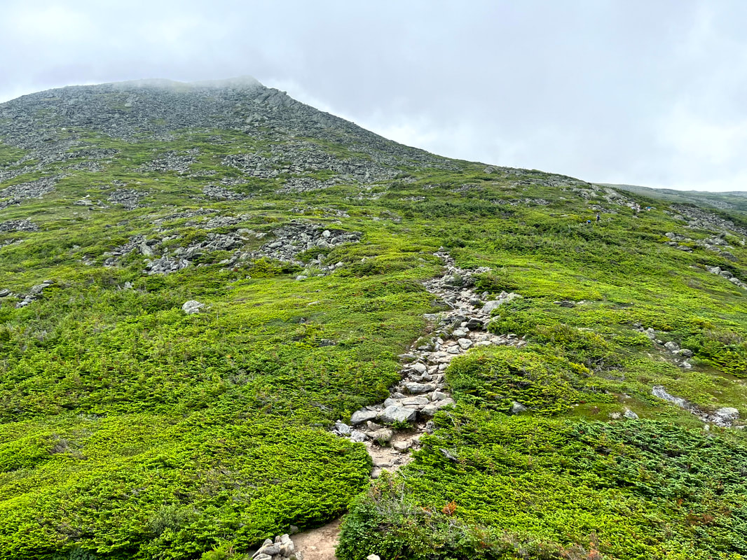
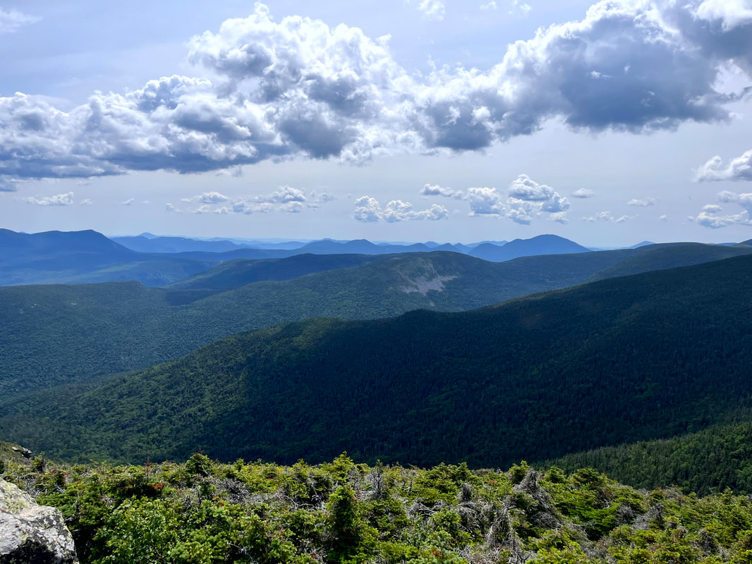
 A brief relatively easy stretch after some serious scrambling, The peak is up in the clouds, which burned off in the epic heat well before we got there.  The trailhead started so innocently... The trailhead started so innocently... HIKED ON JULY 23, 2022 Pictures cannot tell the story. Words absolutely fail. This...was quite a hike. To celebrate the weekend of the first anniversary of my climb up Mount Roberts we hiked Mount Jefferson. The out-and-back on this 5,712 foot mountain (third tallest in NH) via the Caps Ridge trail was about 5 miles. We ended up exploring a bit, making the total hike around 7 miles. This now technically counts as a short hike for us. That said, there was a lot of crawling and clambering over rocks. It was quite the workout in ways that are not usual for many of our walks. It was also absolutely beautiful, with most of the trail unobscured by trees. However, if we were to do it again, I don't think we would take Caps Ridge down. That messed us up a bit. The trail does start in the woods, at the highest parking spot in the White Mountains. For the first few yards it is relatively flat. Then...it climbs and keeps on climbing up out of the trees and on to a number of false peaks and rocky outcroppings that require your full attention. Caps Ridge in on a list of trails known as the "Terrifying 25" for a reason! The views were very distracting, though. 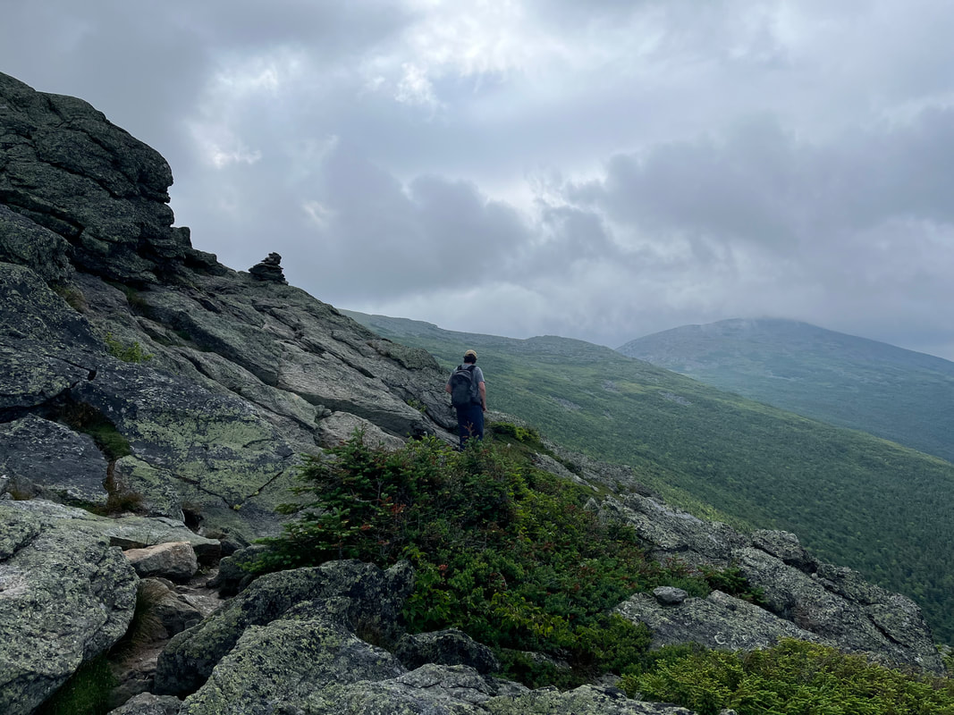 The trail led us up, over, and around many picturesque outcroppings and ridges. 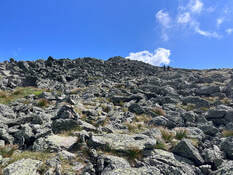 The final push. The final push. We had plenty of company, of course. This is a popular hike and since we could see for miles, we could easily see each other. There were a number of small groups that we leapfrogged with on the way up. As usual, everyone was friendly, some were making good progress in good time. Others seemed to be willing to take breaks and worry less about their ultimate destination. It was all good. 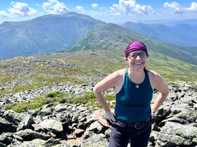 Al in the foreground. Clay and then Washington behind. Al in the foreground. Clay and then Washington behind. The final push was like the House of the Holy Album cover. There were lots of tippy boulders and--with our poles long ago strapped onto our packs--we scrambled to the peak. It was striking...and crowded! There was one of those groups that decided to gather around the very top and obstruct anyone trying to get there as well. We let them be. the view was pretty much the same the whole way around and we planned to do a little wandering anyway. 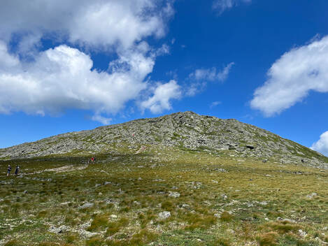 Looking at Jefferson from the Great Gulf Trail. Looking at Jefferson from the Great Gulf Trail. The "Presidents" are connected by a ridge that is relatively level, so once one works hard to get up there, it only makes sense to explore. I cannot recommend this enough! The various side trails--if you are adequately prepared--get you away from the parade of humans a bit and into something that feels more like isolation. There is plenty of nature to go around, of course, so even in a crowd you cannot help but experience the awe of being so high up in an area that doesn't really feel tamable. In fact, the biggest challenge to that vibe is the presence of Mount Washington. From Jefferson one gets a good view of the car road to its peak and of course the buildings at the top. The cog rail whistle--when the wind dies down--is also a thing. 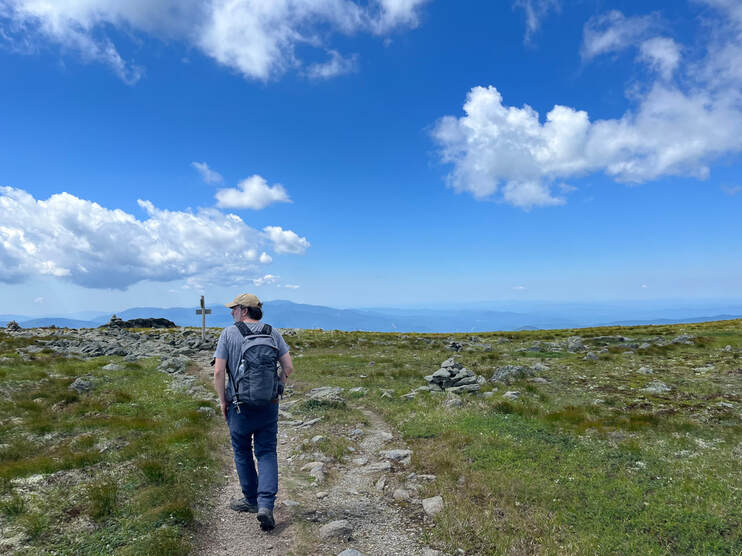 Right before we crossed over the big trail. The view of Jefferson peak (above) is off to my right. Right before we crossed over the big trail. The view of Jefferson peak (above) is off to my right. That said, Mount Adams and Mount Clay make up for Washington's "urban" feel. Also, our wanderings took us onto the Great Gulf Trail (and the AT) for a little while. The massive gap between Adams and Washington may have been the highlight of the trip! We passed a couple of through-hikers heading the other way and then found ourselves back onto the main trail before ducking off it again to a side trail that would bring us back to Caps Ridge. A little before we returned to Caps Ridge we encountered a family who we had seen before on the trail. Experienced hikers and climbers, they had brought their small children up the way we came to get some experience on the rock scrambles and cliffs. "Of course we couldn't go down that way" they said matter-of-factly. This stuck in the back of our minds as we said goodbye and proceeded to do just that. They seemed downright prophetic an hour or so later when I lost my footing on the last of the nasty cliff-things and fell, bouncing a bit before I caught myself by stiff-arming a large boulder. I am glad I did. It was a long way down. Man though, My wrist and shoulder still hurt two days later. No mandolin for me for a while... Still, this was an absolutely great day and a great climb. There is risk in what we do every day whatever it is that we do. The trick is to understand the undertaking and reduce the potential for disaster while enjoying the journey. As I slowly stretch and bend myself back to health this week I will remember the fall, but I will also remember the journey and be thankful I had the chance to take it. 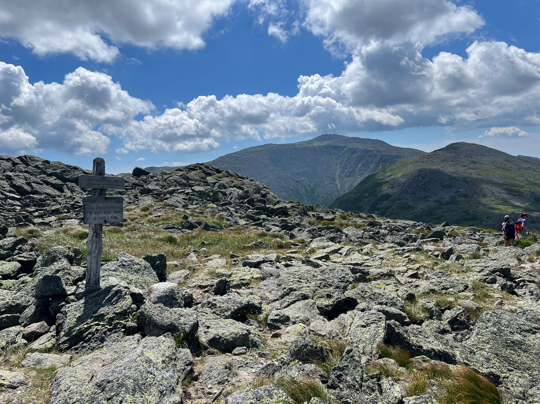 That is Mount Adams looking enticing from the crossroads of a number of trails right off the peak of Jefferson.
0 Comments
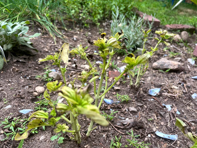 Dead basil...so much dead basil... Sometimes it is good to concentrate on one thing. If we focus hard enough we can block out the noise and worry that burdens our movements most of the time. Of course we return the noise. We can't help ourselves because it is in the air wherever we go. However, the rest we find while homing in on a pleasurable task can be just what we need to sustain us in our return. That may actually be the crux of the project I am on. Hiking, music, writing and preaching all require concentration at a level that draws the detritus away. Each word, each note, and each step is a puzzle that requires attention. Gardening can be like that, too. Which is good, because I am not as successful at reaping the more obvious rewards. It has been a while since I updated you on the small parsonage garden. I have been working on it regularly. Sometimes the work takes a couple hours. More often it is just a few minutes. Up until the heat wave, I have been drinking my morning coffee and answering emails by the raised beds while it is still cool. These days I have to get my miles in while I can, so garden visiting has to wait until the hot midday. The fact is, though, I am learning something new each day. Some of those lessons, though, are harder than others... 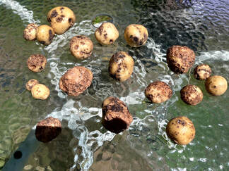 Ewwwww... Ewwwww... Potatoes: Lets start with a mixed bag, shall we? I planted two types of potatoes. This was more than I needed but I was curious about them. Some of my ancestors were Irish and potatoes loom large in their history. I myself grew up in the potato growing state of Maine and lived there as an adult. Potatoes have a special status in a Mainer's heart. After all, we eat way more spuds than lobster. One variety--Irish Cobbler--was a disaster. They had scab and a little rot. The yield was also low. Strangely their neighbors--all Northland Red--were excellent! I don't know why one type succeeded and the other failed but for the first time in my illustrious gardening career...I took a note of it and will get reds in the future. If I feel the need for whites next year I will try Kennebecs...because Maine. 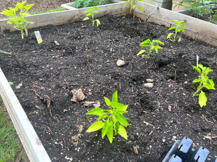 My new Cubanelles...with one yellow squash in the upper right. My new Cubanelles...with one yellow squash in the upper right. Cucumbers: I did not take a picture of the cucumber plant. It is a bushing variety that I got in order to save space and labor. A couple of weeks ago they started to look really bad...or at least some of them did. My first move was to water them religiously. However, they didn't get any better. A consult with my sister-in-law Hanne (who is a professional vegetable farmer, among other things) revealed that they had something called "bacterial wilt." I ended up pulling four plants, leaving me two relatively healthy ones. Peppers: I now have a ton of pepper plants and very few peppers to show for them. I started with a variety including Jedi, shishito, and those round hot ones we used to get at Italian restaurants. Now that the potatoes are gone, I have added cubanelles and one bell pepper. In the heat of summer, maybe peppers will require less work. 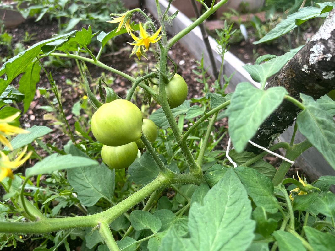 Tomatoes: At least these are going OK. I got a hardy bushing variety. I have no idea how they taste but they live! I spent a little time with these early on, removing early flowers so that strength could go to the plant. Now there are many, many unripe tomatoes that hopefully will survive long enough for me to eat. I am told that the critters don't molest nightshades as often. I hope that is true. I love tomatoes. Herbs: You see that dead basil at the top? There is more where that came from. However, other plants in the herb garden are doing well. Rosemary, lavender, sage, thyme, oregano, mint, chives, and fennel are all thriving. I also have a small volunteer dill plant that would have been used for pickling if the cuke yield was substantially higher. The two "characters" in the herb bed are a stevia plant that I don't know what to do with and some strawberries that I apparently use to distract the local rabbits. 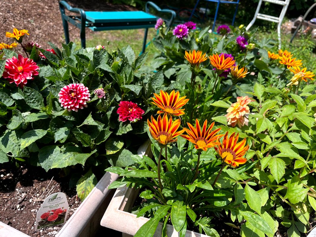  Finally, there are flowers. I keep mine in pots so that the veg has enough space to expand. This year I planted a number of different types but--thanks to the British program "Gardeners' World"--I went in big for Dahlias. They are outrageous and I may have found a new thing to take a deep-dive on this winter when everything is bleak. I bought three common varieties and inter-planted with Gazanias, which are similarly hardy. The effect is perfect for morning coffee contemplation and I usually end that time of day by deadheading those three pots. Yes I play favorites. Next year I will order some more of both and of different types. The Gazania tray I picked up promised a variety but really were just the attractive yellow ones in the picture. I never thought of myself as a flower person. They seem so impractical. This year, though, their impractical beauty has been just what I needed at the beginning of many days. So that is where I am now. I may add something more if the cucumbers finally fail and if there is an herb I would like to establish where the poor basil used to be. Carrots maybe? It feels late for them. I may just expand the greens section, which is rather cramped but produces plenty of arugula and micro-kale to make salads interesting. I did also add one yellow squash. A couple of nights ago I had--I think for the first time in my adult life--a zucchini dish that I liked and considered planting one. Sadly I couldn't find anything at the garden store, hence the compromise-squash. Many of the shops are transitioning to other things now and we are stuck with the seedlings that are left. Still, I needn't have worried about the zucchini. The neighbors have way too many and gave us a couple. We probably don't need more than one plant in the neighborhood. 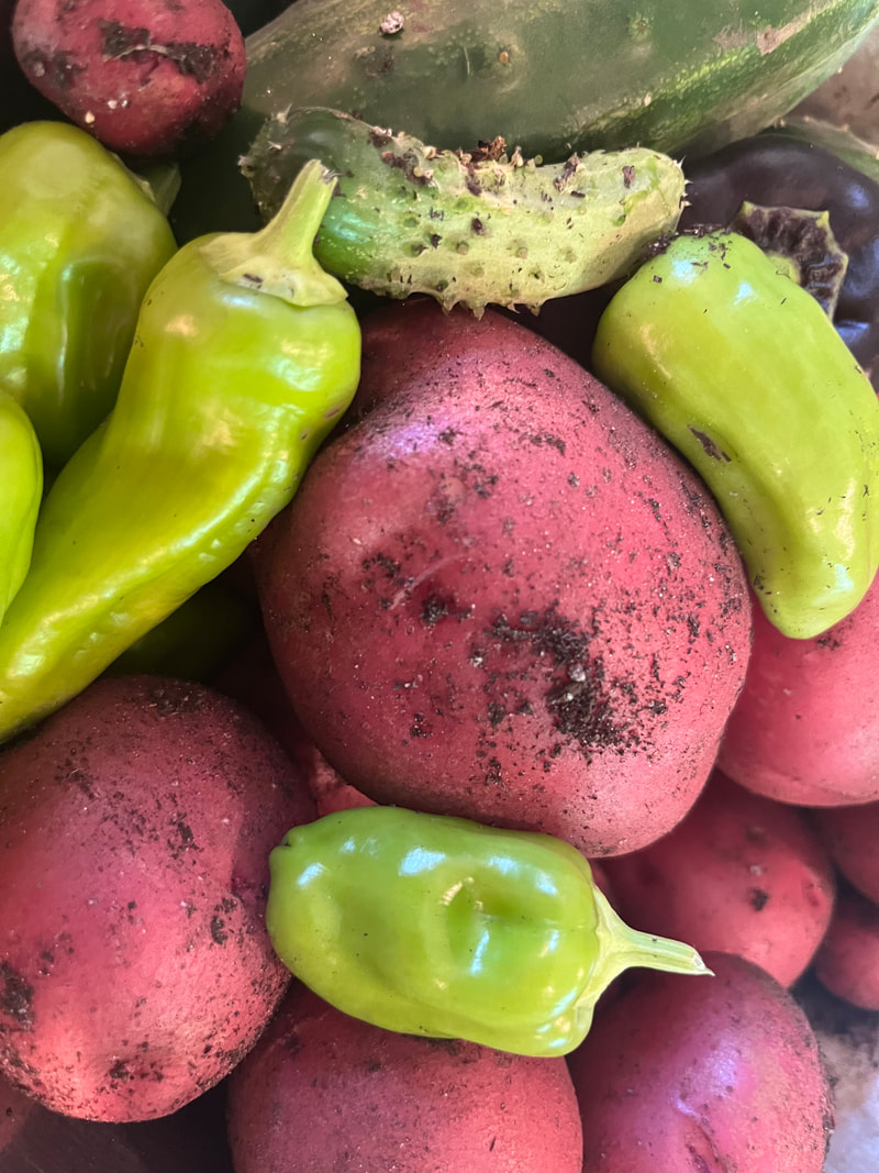 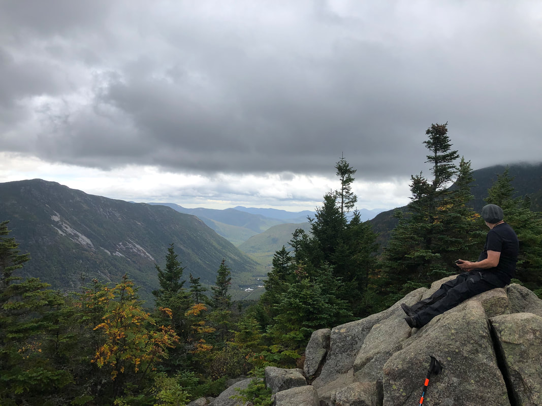 The view from Avalon Perhaps obviously, this is a follow-up to the previous post in honor of my project of outside-of-church spiritual connection. The parameters for this list are even more vague. The previous list encompassed the 10 hikes--plus two bonus hikes--I remember the most. This list is more about the post, itself. There was something about it that I enjoyed outside of the hike, itself, or maybe there wasn't a hike at all. Hikes make up the bulk of the material right now because, well, I am doing a lot of hiking right now. There are other areas and interests, however, and these may require some description. 1) Mount Norwottuck: This post appears on both lists, actually. It made it here because much of it dealt not with the hike, but with Daniel Shays, the Robin Hood of the Pioneer Valley! Local history is totally my bag and since that hike I find myself doing the occasional deep-dive into the "Confederation Period" during the 1780's. 2) Wrestling the Banjo: I am adding this because I love listening to and playing music. There is no hike for this one. 3) A Psalm for the Charles: This was my first post in the Walks Blog. It is the result of spending time canoeing near the parsonage. 4) Pack Monadnocks: This post actually includes a number of shorter hikes in New Hampshire that are worth noting if you are heading up that way with limited time. 5) Skunk Cabbage Meditation: The name says it all... As with yesterday's post there are two "Honorable Mentions." The first is a recent addition concerning the debate over the future of the spillway across the street from my house. About the Spillway outlines my position as well as lamenting the stress this impending decision has put on our community. It also has a number of links both to the issue, itself, and material I have written that reflects my ecological theology. Finally there is my one Garden post. I am doing a lot of gardening these days but I am such a beginner I am having trouble figuring out how to write about it! There will be more soon, though...I promise. 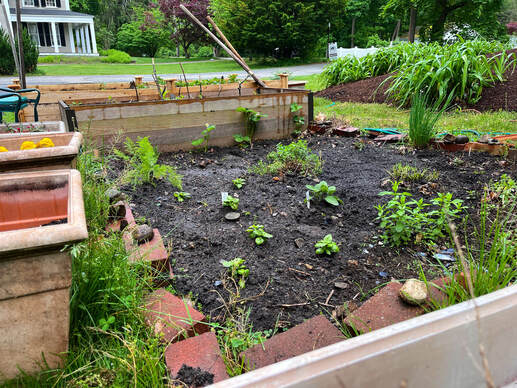 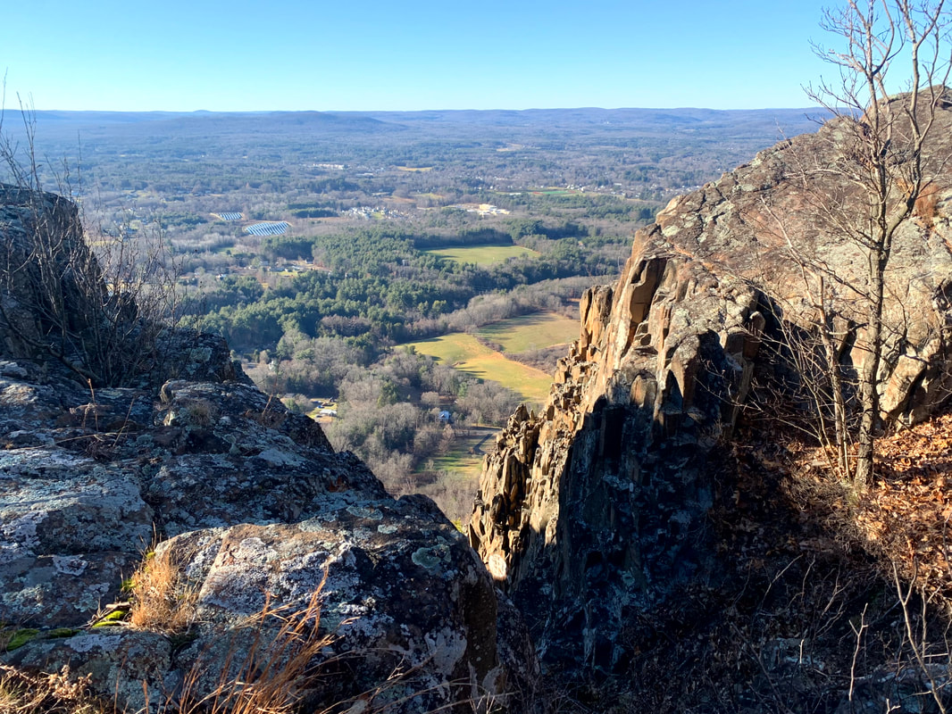 Mount Tom Ledges  One of the views from Roberts, which didn't make the list but deserves a pic! One of the views from Roberts, which didn't make the list but deserves a pic! On July 25 of last year I hiked Mount Roberts officially ending (perhaps prematurely) my post-surgery "rehab" phase. I thought it was the first of my "52 With a View" (52WAV) mountains, which is a hiking list in New Hampshire that I planned to pick away at. Turns out I was wrong and we have photographic evidence that I climbed South Moat years before. Oh well....lets not let the perfect be the enemy of the good. Now--as we drift to the first "Roberts Anniversary" I thought it would be fun to do a "top ten" list of hikes that I have undertaken since then. The system I used was extremely unscientific. Essentially this list reflects the hikes I have thought about the most since. Perhaps they aren't actually the "best" so much as the most memorable. There is something about each of them that calls me back from time to time when I am doing something else. Since that is the primary requirement, they have little in common. There are 52WAV's and NH 4,000 footers (NH 48). However there are hikes in Maine and Massachusetts as well. Some mountains--like Watatic and Wachusett--that I always enjoy are not here. In the end, though, it is a pretty well curated list. Some are short and some are easy. Others are...otherwise. In any case, here they are in descending order as they rank in my memory: 1) Mount Tom Ledges (MA) 2) Welch & Dickey (NH 52WAV) 3) Mount Liberty (NH 48) 4) Mount Norwottuck (MA) 5) Mount Shaw (NH 52WAV) 6) Firescrew & Cardigan (NH 52WAV) 7) Galehead-Garfield Loop (NH 48) 8) Mount Agamenticus (ME) 9) Mount Whiteface and Rollins Trail (NH 48) 10) Mount Tecumseh (NH 48) I also wanted to include two "Honorable Mentions". The first, North and South Twin, may make it on next year's list. They aren't on it now because I haven't had a chance to let it settle in and actually "remember" them. It was just last weekend! Still...that was a pretty good hike. The second, Morgan/Percival and Kearsarge is really two hikes on the same day, which feels like its own category. The first was planned and the next was spontaneous. Barreling up Kearsarge after Morgan and Percival I realized that just maybe I know what I am doing...sometimes. I remember it during despair-time on other hikes. It, too, is special to me but I couldn't figure out how to separate the two hikes. Anyway, here it is. Maybe I should come up with a prize for anyone who hikes them from July 25, 2022-July 25, 2023. That would be fun...  Random view from Welch/Dickey I was out in my garden this morning harvesting potatoes and then planting squash and peppers in their place. They are an experiment. Everything is an experiment these days. While I hope they grow and create food for my labor I do not expect it. I do it because I like being outside, even in this heat, taking part in the ecosystem around me. Its not like a hiking trip at all. However, in the midst of the constant sound and presence of cars, lawnmowers, walkers, and leaf blowers there is some nature to be had. It is in the garden and under the trees where the landscaper doesn't go. Sometimes, it is in the sound of the river that runs just across the street. The Charles River (called the "Quinobequin" in Algonquin) here in Natick is a catalyst for argument these days. You see, there is the issue of the dam (an earthen barrier referred to more often as a park) and the spillway (a concrete barrier colloquially referred to as a dam). Regulators say that something must be done. It is unsafe as it is and the solution comes down to repair of the spillway--which would require removing all the trees (and therefore the ecosystem) in the park--or removal of the spillway (which would mean restoring the flow of the river and lowering the water level above it as well as taking away our tiny waterfall). Emotions are high. It will be a change either way and people are rarely comfortable with change. I feel it too. I know that--after the better part of two decades living here--whatever will happen will feel a little bit like a loss to me. I have raised my children by the river. We have paddled as far as we could manage both upstream and down. I walk past it many times each day and wave to the people I know enjoying their coffee and watching the water go by. I have sat by the spillway with family, friends, and congregants having some fairly momentous conversations. I have made observations concerning the local flora and fauna here in the weblog. I will miss the way it is now and am grieving what is to come. 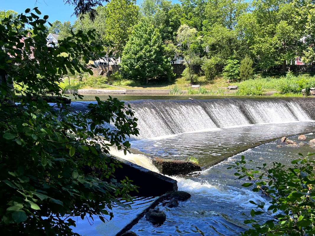 The spillway this morning. I have friends on both sides of this debate--repair v. removal--and I understand why people feel so strongly about this issue. We are talking about our home and our homes. However, things have gotten heated in some quarters in ways that reflect the current political landscape. No doubt they will continue to be. On the social networks (which I am not fond of but have to use) it seems that we cannot help but slide a bit from finding our way together into devaluing the opinions of others. There is lots of snark these days. There are arguments about whose opinion "matters most." Just like on the national stage each side even has a different language for the discussion. I will tell you my opinion, but fellow Natickites already know it because I used the word "spillway" instead of "dam" to describe...um...well...the spillway. I have recently noticed that most (but not all) of my neighbors have put up signs in favor of maintaining the spillway in South Natick. This does not surprise me. I will not hazard specific reasons because they can speak for themselves. It is a nice spot and--as I described above--part of a profound set of memories and connections for all of us who live on its banks. That said, I cannot agree with them. I am in favor of keeping the trees in the park and removing the spillway. There are reasons for my position and, again, if you live here you probably already know what they are; Removal of the spillway would increase biodiversity, expanding the range of a number of species. This is something I believe in strongly. Heck, I have an ecology blog. Also, restoring the river has been a priority for the local Nipmuc people for a long time. After all we have done to Native Americans in this country, removing a spillway that serves no clear purpose seems literally like the least we could do. Finally, removal and restoration is the most cost-effective choice. This town is growing and will be for some time. Our needs are growing too. I would like the money to be put elsewhere in support of this community. There is also another concern. Maybe it is a personal one but I will share it anyway. When I decided to become a minister (I was 19) I decided also to walk a path of faith as I see it. Seminary, fellowship, and ordination reinforced that decision. My theology has changed but my walk has not. Part of that walk is doing what you think is the right thing to do. I fail plenty of times. I am a pastor not a saint. That said, When faced with as clear a decision as this--where the ecological, cultural, and economic impact point in one direction--I cannot go back on that walk because right now it might feel inconvenient to me. I believe the world isn't about me. It is about the "Great Whatever." It is about living in harmony with nature and with each other. It is about taking the time to set aside my own ego to work for restoration of rivers and, frankly, of many other things. I have to stand on principle, even if I don't know exactly what will happen next. Of course, another part of the walk of faith is understanding that change--the very thing that makes us anxious--does, in fact come. We cannot stop it. There will be change either way. Things will not be the same. Both paths can lead us to wonder what it will be like in our neighborhood in a few years. However, I have spent a great deal of time on and beside rivers without dams and honestly they are pretty, too. I expect that--no matter if the spillway is there or not--people will still be called down the banks of the Quinobequin with our coffee and our thoughts for a very long time.  This is a view upriver from the spillway. This post is already too long. I am going to stop now and just leave you with some links to more information that might help if you are interested in either my reasoning or the specific issue here in town. First, my ecological theology is in development. However, I have posted a three-part "curriculum" that I wrote here at the Walks Blog; Environmental Literacy In Creation I Environmental Literacy in Creation II Environmental Literacy in Creation III Also here is the link to the FAQ page from the town government. It is regularly updated as we learn more about the project and its impact and is worth looking at. Generally the evidence here--written by engineers and scientists with expertise in dams and their removal--supports spillway removal. So... Here is the webpage of Save Natick Dam Finally one version of a psalm I wrote for the river as the first thing I posted here.
 I forget but...I think this is one of the spectacular views off the first overlook on North Twin. That would be the shoulder of South Twin on your right. 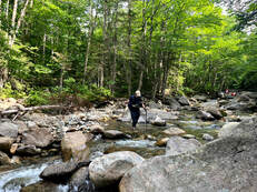 Wading through the second-widest of the crossings on the way down. My feet were so happy! Wading through the second-widest of the crossings on the way down. My feet were so happy! HIKED ON JULY 16, 2022 Man my legs hurt... This hike over the Twins was quite an undertaking. It was a twelve-miles total out-and-back over North Twin (4,760 feet) to South Twin (4,902 feet) then back over North and on down the way we came. We got off fairly early--a little before 5am--and were at the trailhead by 8. The parking lot was already full and we were among the many who found a parking spot by the side of the road. It wasn't the most crowded trail we've encountered--that would be our fall hike up Zealand--but it was still much more than we have seen at other times. It is a summer weekend in the Whites! This is what it looks like. Fortunately the crowd was one of the friendliest we have encountered. Occasionally you get grumpy people who are unhappy to see you. I believe I mentioned that in my Moriah post. Not on this day, though. I will spare you most of the details but there was a lot of shared picture-taking, friendly chit chat, and general encouragement both given and received. The hike up is different in a couple of ways worth mentioning. First, there are a number of somewhat challenging river crossings. This trail is not recommended during the spring runoff, in fact, when the crossings can be downright dangerous. There is also an unofficial "bushwhack" that helps folks get around them. However, we opted to ford them as the levels had gone down substantially and, well...it was fun. That said, instead of jumping from rock to rock, we bought our sandals and waded through. Taking the risks of an errant stick on the trail, we kept our sandals on until we crossed the last big stream. With boots back on--already a few miles in--we started our climb in earnest.  This is not the nasty gravel part, but part of the trail on the absolutely gorgeous ridge between the peaks. 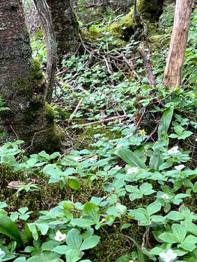 The next big problem we encountered was the condition of the trail. People have been hiking the Twins for a very very long time and the trail has been worn down over the years. Often when this happens (and on some parts of this hike) that means smooth and sometimes-slippery ledge. In this case, however, there were large stretches of small, loose rock that shifted underfoot. It wasn't a game changer by any means, but it was annoying. It would have been nice to gain some firmer footing. Our slow progress, however, gave us a chance to check out the foliage. This hike has incomparable ground cover with plentiful and diverse flowers and moss to examine during water breaks. I found it to be a nice consolation for the upward slog. On the way up North Twin we encountered a number of people going our way. We leapfrogged each other from time-to-time, talking each other through the river crossings in one case and celebrating the "first 4,000 footer" of a confused puppy in another. There really is a bit of a community among the people who do this frequently. Peak baggers belong to the same Facebook groups and follow the same folks on Instagram. My eldest son is hiking the Appalachian Trail and it isn't as intense as that--we don't camp together every night for months at a time--but we do occasionally see the same faces and we know we have the same hobby. On this day everyone was in a talkative mood, which helped in the darker moments of the climb. 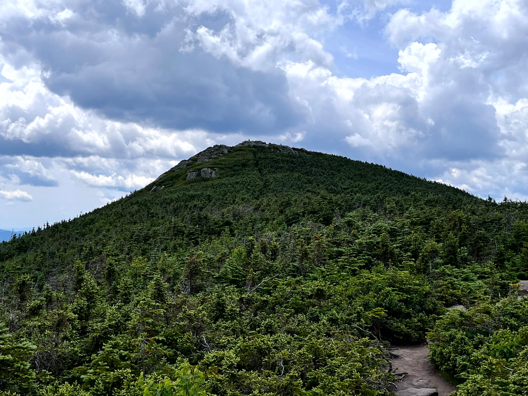 The peak of South Twin from the ridge. The peak of South Twin from the ridge. 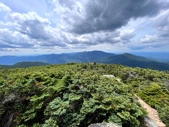 I have to admit there were moments when I was pretty close to despair on the way up, but once we reached the first overlook (and celebrated the puppy) things improved immensely. North Twin featured a couple of beautiful spots for a rest and a snack. Then we had the opportunity to hike across the ridge to the peak of South Twin. I have mentioned before that I love a good ridge trail. This one was special. Also, it was super-easy! I think I enjoyed it more than the peaks, themselves. On this hike, if you do all the work to climb the first mountain it is worth taking the time to bag the second. After all, the work is done! The 1.3 mile walk to South Twin was a great recovery opportunity with semi-obscured views and more of that diverse alpine ecosystem to enjoy. Once we made it to the summit, we were blessed with 360-degree views. I did not take a video because we were also surrounded by lots of fellow humans. Still, even with the crowd, it was quite a sight. Here on South we met a number of high schoolers, one of whom waxed lyrical about the mountain we were on and the mountains we could see. We had an excellent view of the "Presidents." Washington--with its towers and cog rail--was the most obvious, of course. However, the shear number of mountains within view rivaled the top of Liberty and seemed to stretch on forever. 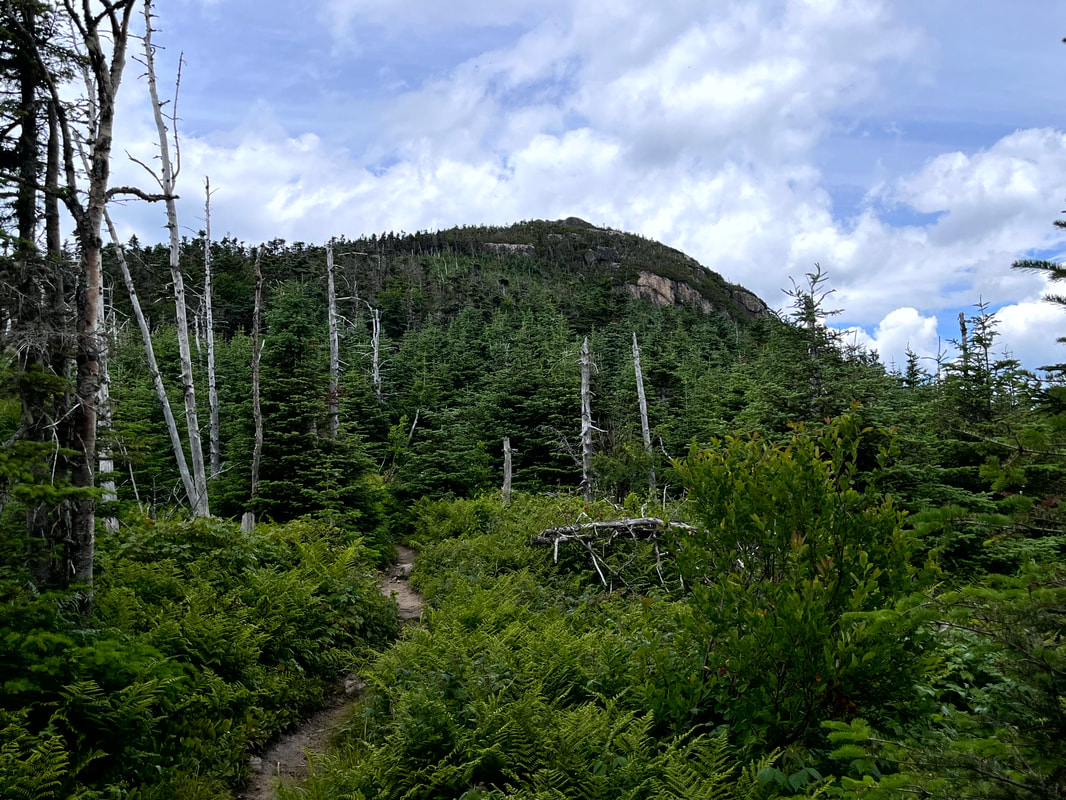 This is North Twin from the ridge. It was a bit more of a scramble back up. Turning around and crossing the ridge we once again approached the north peak. It was a bit of a struggle to climb back up the scrambles we had already climbed down but, really, it wasn't so bad. We stopped at both the outlooks on North once more and then proceeded to our cars. We crossed the river again, and again, and again. we leapt from rock to rock for the first one then I switched to sandals. Al jumped one too many rocks and got her feet wet so switched to sandals for the last crossing and hiked out that way. I will do this hike again sometime. It probably won't be too soon, though. South Twin was #24 for me on the NH 48 list which is exactly halfway. Also, I am at # 11 of the 52WAV. I would like to get back to those. Still, what a day... 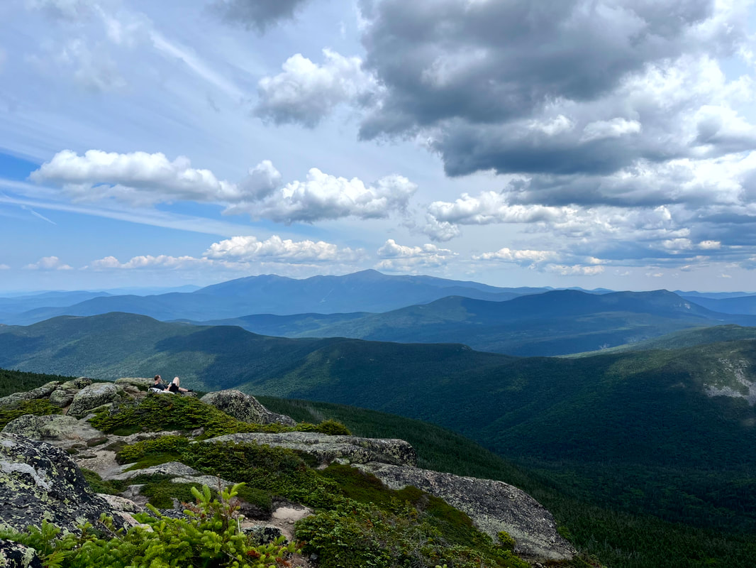 Part of the scene on South Twin. We all envied that guy and his sitting spot...but we did OK. Dear Folks, I am in the process of catching people up with some early hikes and other encounters with nature that I thought people might find interesting as part of a "How It Began" (HIB) series. Mostly this will describe specific hikes and perhaps some lessons learned along the way...if there are any. They are meant to be short and, perhaps helpful in some way to other hikers or fellow-travelers. I will post the dates of when I hiked a specific mountain since the ones in this series are NOT posted at or near the date I actually hiked them. To add further confusion, I am not doing them in order! Here is a post about a winter hike. We did so many and have posted so few... 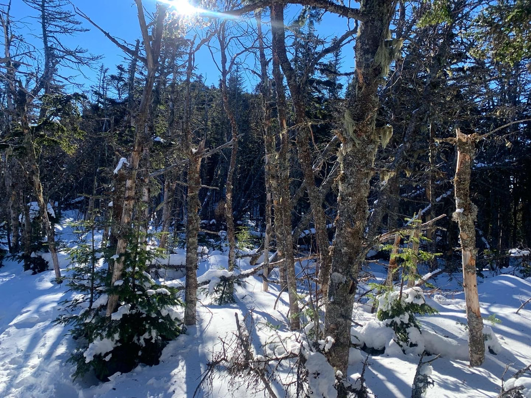 Hiked On: January 16, 2022 In the back of my mind during this whole hike was the idea that I might have done something very stupid. It was 15 degrees below zero at the trailhead when we started up Mount Liberty. The socials that we follow were filled with dire warnings about climbing on that day. Mount Liberty is 4,459 feet tall. The out-and-back we had selected was a little over 7 miles, which means it was steep. Other than the temperature (and the abundant snow and ice) this wasn't our hardest climb. The snow and ice do make a difference, though. The freezing temps make a difference too. Our packs were heavy with snow shoes, spikes, emergency equipment and layers. Still, there we were at 7am ready to go. So, again, I couldn't help but think I made a mistake and should have done something else with my day. 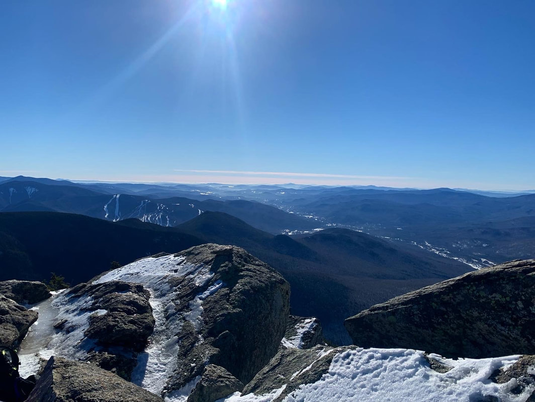 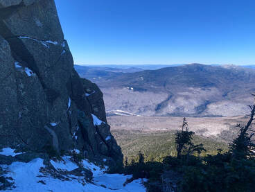 As a hike, it is fairly straightforward. It starts on a multi-use trail that we had been on before as there are a number of other climbs--for us winter climbs--that can be reached from that path as well. Then, we got a long period of relative flat before climbing...and climbing steeply all the way to the top. While on that flattish part, I started to have temperature regulation problems. As anyone who has spent time outdoors in the cold can tell you, there are moments when one's internal thermostat goes crazy. If you don't figure it out then hypothermia will set in. It took me a while to figure out what to do and we gave serious thought to turning back. Finally--after experimentation--I realized that I was running too hot for the amount of clothing I was wearing. This was the first lesson. I recalled going down Mount Willard a couple weeks before and witnessing a number of children on their way up desperately trying the shed layers while their parents just as desperately tried to make them keep the layers on. The kids were crying loudly, steam rising up out of their jackets. I remember thinking to myself that the kids needed to cool down to warm up--you don't have to wear all your layers all the time--and I realized I was doing the same thing. My concern over the temps had caused me to overdress for climbing. I was being just like those parents re-zipping jackets and cramming hats back on to sweaty heads. Since my parents were nowhere nearby I shed some layers and after a while things leveled out. I kept the hat, though, a hunter-orange number, and my gloves. Extremities are the first to go, my friends. Still, despair--my constant companion--was a problem. I have this issue below the tree line, particularly in winter. The trail, you see, just goes on and on and...I hate snow. The walk was slow and the struggle was real. We took many rests but the rests weren't that satisfying either. After all, I was cold. Finally we broke out onto a ridge and while there was still plenty of up to go, at least I could see out and around me to the winter landscape. Also I could see where I was going. Liberty is famous for its gigantic rock near the peak. We knew to point ourselves toward it and keep on keeping on. Also, the sun was out and that exposure warmed us up a bit after the shady trails below. As I have experienced in all seasons, a good ridge lifts the spirits immensely.  We finally broke out on the top and could see for miles all the way around. A small group had gathered there. Some were people we had been walking adjacent to for hours. Others had come over from Mount Flume, which we had done before the snow. About a third of them were carrying small sleds. I had done a bit of butt-sliding by this point but I had never imagined bringing a sled and treating a 4,000 footer as a personal sledding hill. It looked like fun. Butt-sliding is somewhat controversial in the Whites. Some love it. Some hate to hike down the shear track that they leave. I am a moderate on the issue. It is pretty convenient, though, and sometimes necessary of there have been a lot of sledders before you. We slid down a good chunk of this mountain ourselves using our snow pants, but I have to say...we never caught up to the actual sledders. In the end this was an important hike for me. It started rough and got dark (emotionally not meteorologically) a few times. In the end, though, I made it. I learned I could do something like this. I also learned that when people start saying "stay home unless you know what you are doing" sometimes at least...I do know what I am doing. Of course I have modified a number of hikes since because I knew what I was doing and didn't want to do a thing. After this hike, though, I learned to trust my judgement a bit more. I remembered that I had the authority to adapt to what my body was telling me. I also learned that even though I do not like snow...there are reasons to be outdoors in January. 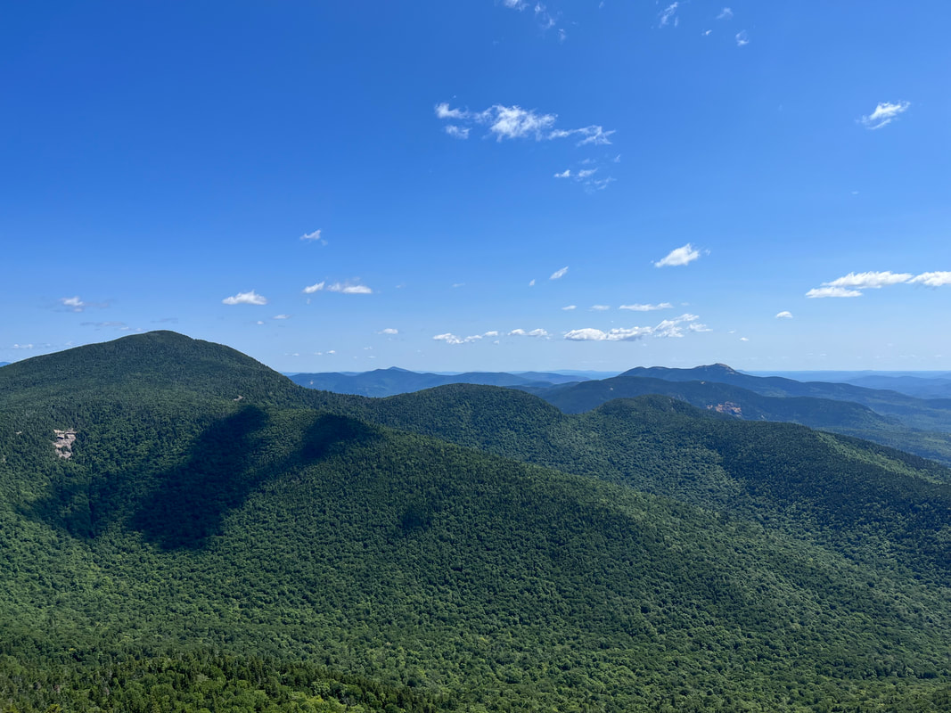 That is Passaconaway on the left. The high point in the distace on the right is Chocorua and right in front of it is Paugus. 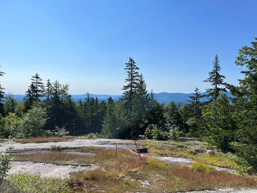 HIKED ON JULY 10, 2022 Hiking out of the parking lot on our way to the Blueberry Ridge trailhead we passed the time of day with another hiker who said two things that have proven pretty much true. One was that a person would have to look pretty hard to find a place as beautiful as the Sandwich Wilderness Area and the other was that--given the weather--there was no way that our various hikes would be any thing other than epic. We could only agree. The first we had already experienced. We have both hiked--alone and together--a number of trails in this area and each time we were struck by the foliage, views, and landscape. The second had special meaning. The last time we parked in that lot was to hike Passaconaway a couple of weeks ago on a day when the weather was definitely more dangerous. That story can be found in my Passaconaway post. This one is about a different day. 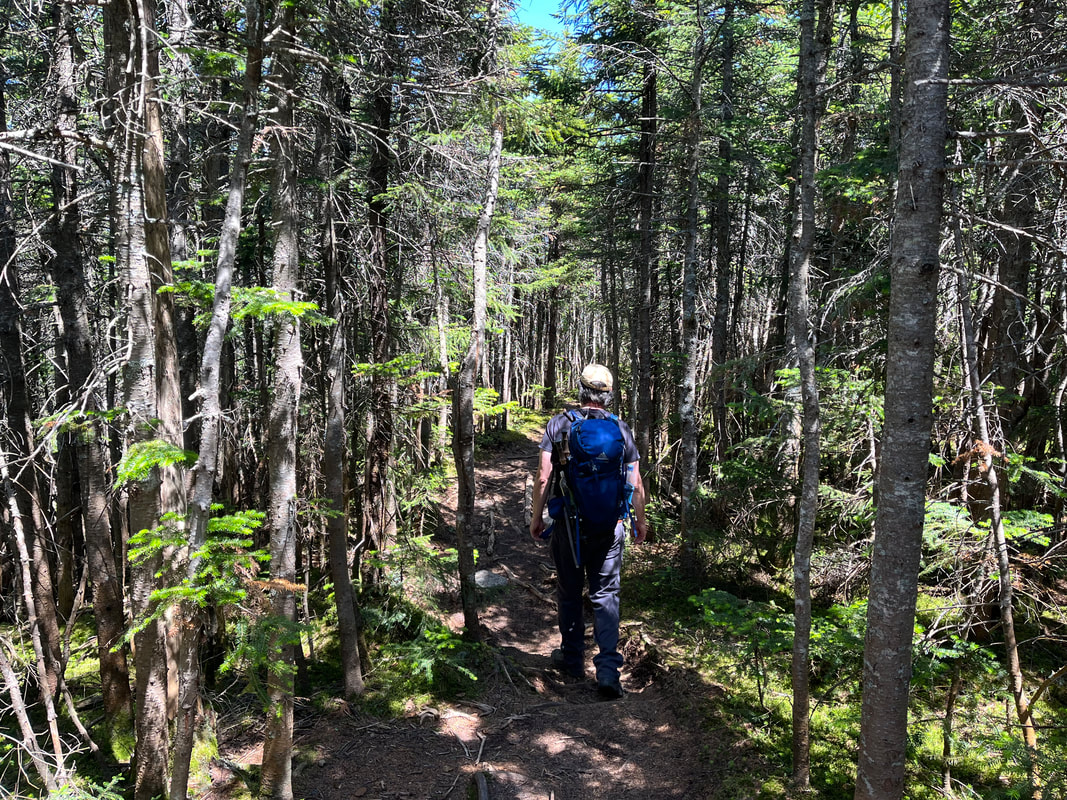 On the Ridge. 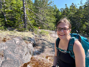 After that other hike we decided to make our return a priority, to climb up it's neighbor, Mount Whiteface. If we had enough in the tank we also thought we would hike the ridge--on the Rollins Trail--between the two mountains and peer into "the bowl". The space made by the two peaks and the ridge has never (at least during recorded history) been logged or experienced a fire. This, honestly, interested me more than the climb. The trail at first was just like Passaconaway, which is to say it was a road. You can check the other post for a further description. Then we turned into the woods and started to head up. Whiteface gets its name from the prominent stone cliff that can be seen from ground-level, so the trail--after a gradual start--became quite steep with a number of potentially-dangerous rock scrambles. We congratulated ourselves on waiting for a dry day for this. There were a number of ledges along the way, each with a similar, fabulous view of the wilderness area, some with Lakes Winnipesauke and Squam in the distance. We could see mountains we had already hiked and a number that we had yet to hike. Of course, we could also see into that bowl, which was breathtaking as well. I will say that the scrambles were a challenge. We stowed our hiking poles in order to use our hands to get better purchase. As we went up, we encountered a couple and their dog attempting a barely controlled descent. A few people we talked to over the course of the day decided to hike the ridge to Passaconaway instead out of concern for the potential for injury going back down the ledges. Al and I were not that worried, but we did end up on the Rollins Trail. The "true" peak of Whiteface is just a spot on the woods past all the cool stuff so we passed the point of no return in search of it. 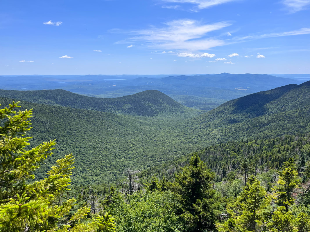 Looking down into the Bowl Research Area from the ridge. 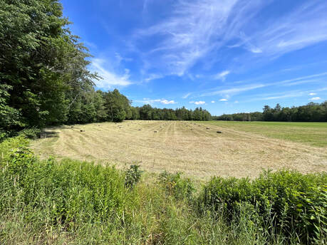 I have always loved a square bale. I have always loved a square bale. I have to say... the trail between the peaks was my favorite part. The relatively untouched nature of the ecosystem gave the whole area on the ridge a sort of elfy vibe. There were plenty of thin, straight trees and a diversity of species that changed every few yards. The abundance of rotting wood that supported this system was covered in various mosses. There was a breeze and every once in a while...a view into that bowl again. Also, this part was pretty flat, which was a nice change from the boulder climbing and the inevitable climb down Dicey's Mill Trail. After that experience, we turn right at the intersection of the spur to the peak of Passaconaway. The left would have taken us to the top and a loop with some limited views. However, we had just been there. Honestly, as an attraction on this journey, it came in a distant third anyway. I mean, it was worth climbing when we climbed it, but it will be a while before we feel moved to do it again. We walked down Passaconaway's side back to the road and then to the car, set in a hay field. This very hike I would do again in pretty much the same way. Both the ridge and the ledges of Whiteface lived up to the hype. It is a steep and rough climb in places, though. Also, it was a touch over 10 miles. If you decide to do this one, pick a clear day and take your time. Frankly you will want to because there is so much to see. Dear Folks, I am in the process of catching people up with some early hikes and other encounters with nature that I thought people might find interesting as part of a "How It Began" (HIB) series. Mostly this will describe specific hikes and perhaps some lessons learned along the way...if there are any. They are meant to be short and, perhaps helpful in some way to other hikers or fellow-travelers. I will post the dates of when I hiked a specific mountain since the ones in this series are NOT posted at or near the date I actually hiked them. 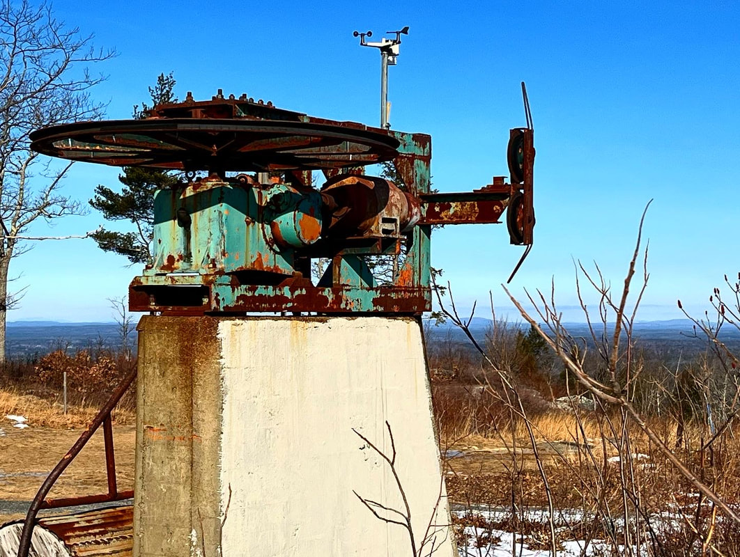 JANUARY 24, 2022 After our hike up the Osceolas, my brother Dan and I decided to head out closer to where he lives in Maine. Our eventual destination was Mount Agamenticus. This tiny mountain (about 600 feet) is yet another monadnock, boasting views well over its weight class. Also...you can see the ocean, which is cool. I am unsure the exact distance we hiked but it was probably between 4 and 5 miles. We intentionally explored a bit...then we were briefly lost. It was all good, though as it was a spectacular place to be. Most of my winter hiking up that point had been in the White Mountains of 2,500-4,500 feet (and yes, I will get to at least some of them). This, however, was different, not just because of the height but because there was very little snow. Of course the absence of snow sometimes means a great deal of ice, so microspikes were definitely in order. 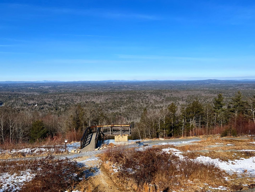 As promised, this little peak boasted some fabulous views. Back in the day, it was the home of the "Big A" ski area, with night skiing, snow cannons, and chair lifts. It is funny to think of this now when most ski mountains are quite more involved. That said, you can see how it made sense. The location of York in southern Maine near both Maine's and New Hampshire's population centers sustained the business from 1966 to 1974 but it must have been hard to compete against the big guys. Anyway, it was a great day. The company was fabulous and the trails had a lot to offer. As I have mentioned before, I also like a little decaying machinery in my views. There was plenty on Agamenticus in the form of Big A ski gear. 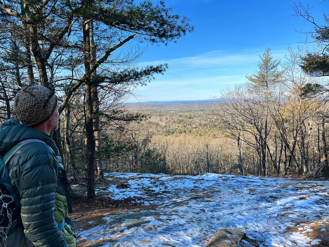 And that flat thing out in the distance? That is the ocean, my friends.... Dear Folks, I am in the process of catching people up with some early hikes and other encounters with nature that I thought people might find interesting as part of a "How It Began" (HIB) series. Mostly this will describe specific hikes and perhaps some lessons learned along the way...if there are any. They are meant to be short and, perhaps helpful in some way to other hikers or fellow-travelers. I will post the dates of when I hiked a specific mountain since the ones in this series are NOT posted at or near the date I actually hiked them. 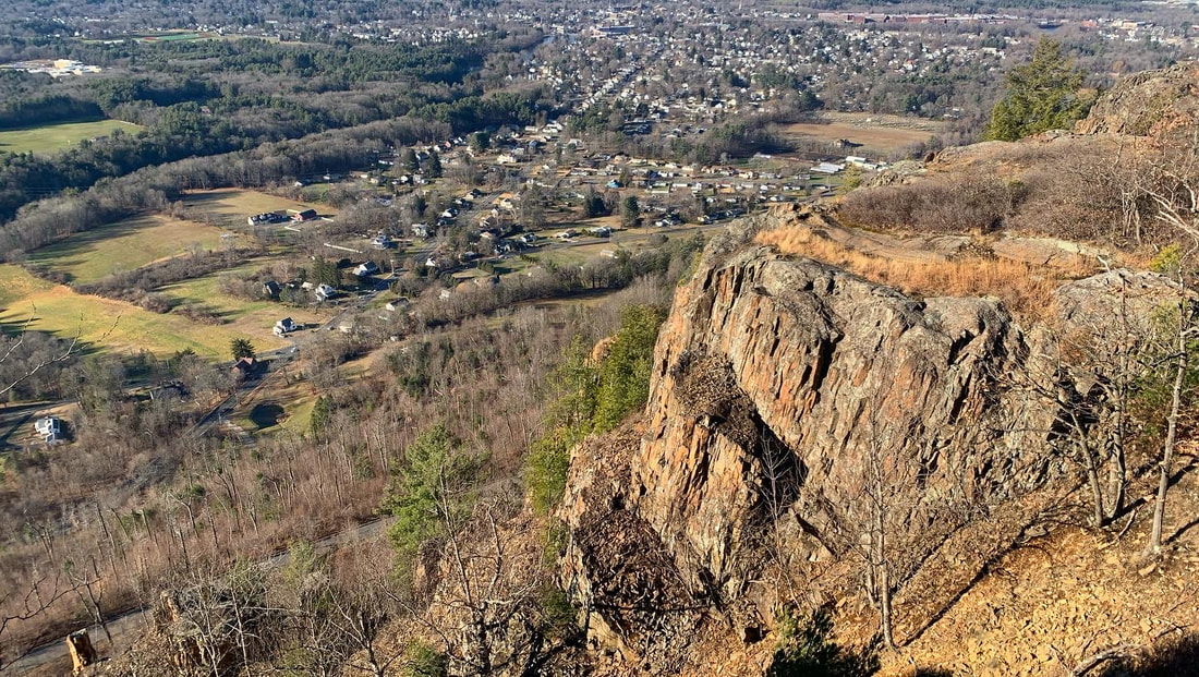 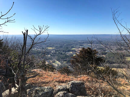 DECEMBER 14, 2021 Sometimes there are good things on even the least promising of days. This was a busy day for me. Holiday prep was in full swing. We had family things and church business going on. My post-surgery back had taken a turn in the wrong direction. There were other tragedies--not my story to share and therefore not discussed here--that occurred even as we took this walk. It is hard sometimes to separate all that from the trip up to Mount Tom by way of the Mount Tom Ledges, but I will. Somehow in the midst of all of the mess of life, this hike stands out as one of the best. Now, some of you may recall that the name "Mt. Tom" has already come up in my post about the Tom, Field, Willey, Avalon post about a loop over three 4,000 footers and one slightly shorter (and super-gorgeous) mountain in New Hampshire. This is not the same Mountain. Apparently "Tom" is an evocative name when it comes to these sorts of things. This hike occurs back in the Pioneer Valley, my old friend. It is yet another rocky ridge surrounded by flat plains enabling stunning views wherever the trees part, or are low enough. This hike was about seven miles out and back and featured around 1,200 feet of elevation. I really did not feel well. I was tired and distracted by a million things. We almost stopped at the first overlook (which was fabulous) but then--after a quick rest--we continued forward at first tentatively, then with purpose. I had to stop occasionally to answer emails and check messages which is something I never do on the trail. This really was a different time, though, so I made a couple exceptions. However, perhaps the chaos outside the moment made the time on the ledges that more special. 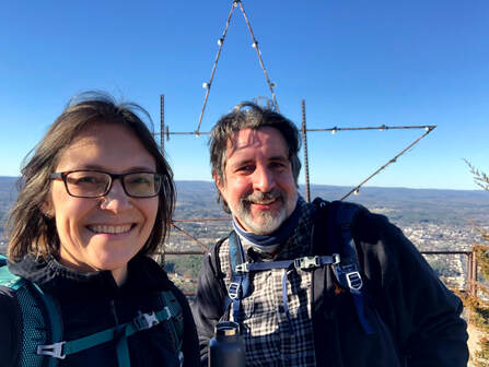 After that first overlook the landscape became rocky and rolling with constantly changing views into the farmland below. We covered a couple of smaller peaks and then moved along toward Mount Tom, itself. One of the big differences in hiking in Massachusetts is that there is much more evidence of humanity. With each view we could see houses and sometimes whole towns stretched out below us. We also passed cell towers, power lines, and windmills. There were decaying and somewhat-unidentifiable pieces of metal and glass sticking out from the bushes. There were service roads as well. Finally, on the very top of Tom there were a few industrial-looking buildings obviously there to maintain the radio towers that dominate the peak. Also on the peak was a massive metal and wood star with Christmas lights on it. It turns out that this star is a local tradition in Easthampton. I love Christmas lights. Somehow all this evidence of humanity worked. There wasn't any "litter" to speak of and I loved the industrial elements. They seemed to go with the gray and hardy rock that was everywhere. Yes there was evidence of people communicating, celebrating, and making the mountain a centerpiece of their lives. That--at least on this hike--made all the sense in the world. After a while we turned back around and experienced all the views again. I am tempted to hike this in every season eventually. I can only imagine that it has plenty more to give. 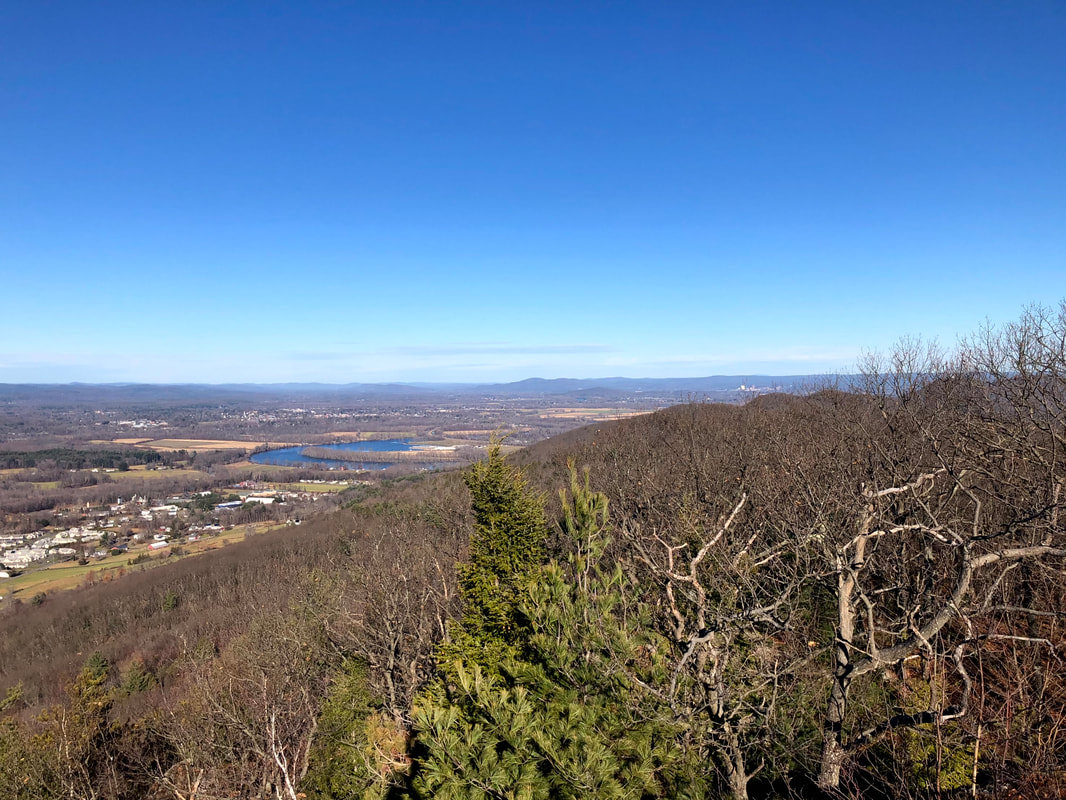 |
Adam Tierney-EliotI am a full-time pastor in a small, progressive church in Massachusetts. This blog is about the non-church things I do to find spiritual sustenance. Archives
June 2024
Categories
All
|
 RSS Feed